A floodplain is the area bordering a river that naturally provides space for the retention of flood and rainwater. Floodplain soils are generally very fertile and they have often been dried-out to be used as agricultural land. Floodplains in many places have also been separated from the river by dikes, berms or other structures designed to control the flow of the river. They have also been covered by legacy sediments.
Major floodplains roles have thus been lost, due to land drainage, intensive urbanization and river channelization. The objective is to restore them, their retention capacity and ecosystem functions, by reconnecting them to the river.
Restoring the floodplain roles requires measures such as:
- modification of the channel,
- removing of the legacy sediment
- creation of lakes or ponds in the floodplain
- new/modification of agricultural practices,
- afforestation, etc.
- plantation of native grasses, shrubs and trees
- creation of grassy basins and swales
- wetland creation
- invasive species removal
- riparian buffer installation and development
 |
 |
|
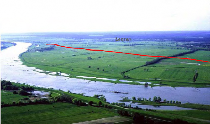
Floodplain before flooding Source: Thomas Borchers’ presentation, |
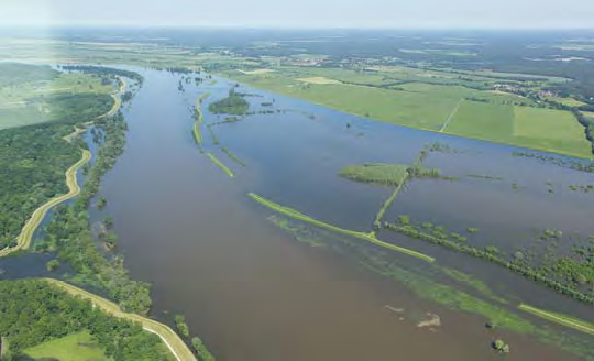
Floodplain during flooding Source: Thomas Borchers’ presentation, NWRM Workshop 1 (from: Nora Künkler) |
| Benefits | Level |
|---|---|
|
BP1 - Store runoff
|
High
|
|
BP2 - Slow runoff
|
High
|
|
BP3 - Store river water
|
High
|
|
BP4 - Slow river water
|
High
|
|
BP5 - Increase evapotranspiration
|
Medium
|
|
BP6 - Increase infiltration and/or groundwater recharge
|
High
|
|
BP7 - Increase soil water retention
|
Medium
|
|
BP8 - Reduce pollutant sources
|
Medium
|
|
BP9 - Intercept pollution pathways
|
Medium
|
|
BP10 - Reduce erosion and/or sediment delivery
|
High
|
|
BP11 - Improve soils
|
High
|
|
BP12 - Create aquatic habitat
|
Medium
|
|
BP13 - Create riparian habitat
|
High
|
|
BP14 - Create terrestrial habitats
|
High
|
|
BP15 - Enhance precipitation
|
Low
|
|
BP16 - Reduce peak temperature
|
Medium
|
|
BP17 - Absorb and/or retain CO2
|
Medium
|
|
ES1 - Water storage
|
High
|
|
ES2 - Fish stocks and recruiting
|
High
|
|
ES3 - Natural biomass production
|
High
|
|
ES4 - Biodiversity preservation
|
High
|
|
ES5 - Climate change adaptation and mitigation
|
Medium
|
|
ES6 - Groundwater/aquifer recharge
|
High
|
|
ES7 - Flood risk reduction
|
High
|
|
ES8 - Erosion/sediment control
|
High
|
|
ES9 - Filtration of pollutants
|
Medium
|
|
ES10 - Recreational opportunities
|
High
|
|
ES11 - Aesthetic/cultural value
|
High
|
|
PO1 - Improving status of biology quality elements
|
High
|
|
PO2 - Improving status of physico-chemical quality elements
|
High
|
|
PO3 - Improving status of hydromorphology quality elements
|
High
|
|
PO4 - Improving chemical status and priority substances
|
Medium
|
|
PO5 - Improving quantitative status
|
Medium
|
|
PO6 - Improving chemical status
|
Medium
|
|
PO7 - Prevent surface water status deterioration
|
High
|
|
PO8 - Prevent groundwater status deterioration
|
Medium
|
|
PO9 - Take adequate and co-ordinated measures to reduce flood risks
|
High
|
|
PO10 - Protection of important habitats
|
High
|
|
PO11 - Better protection for ecosystems and more use of Green Infrastructure
|
High
|
|
PO12 - More sustainable agriculture and forestry
|
High
|
|
PO13 - Better management of fish stocks
|
High
|
|
PO14 - Prevention of biodiversity loss
|
High
|
|
ES5 - Climate change adaptation and mitigation
|
Low
|