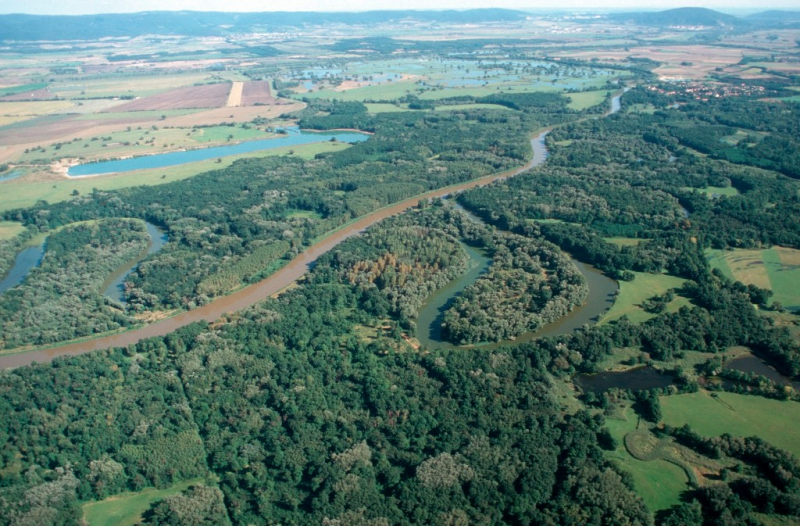
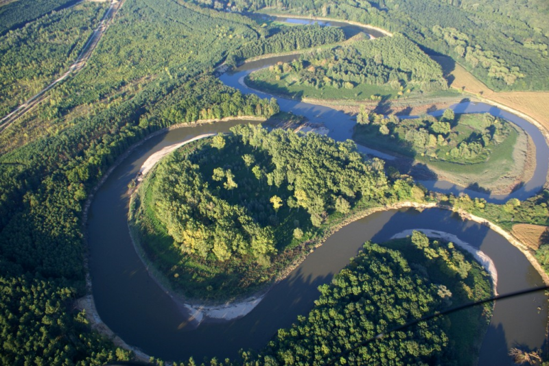
A river meander is a U-form taken by the river, allowing it to decrease water velocity. In the past, rivers have been straightened by cutting off meanders. Many rivers in northern and Western Europe have been straightened and channelized to, for example, facilitate log floating and/or speed up the drainage of water and control/limit the river bed movements. Channelizing was also a way to gain land for cultivation. River re-meandering consists in creating a new meandering course or reconnecting cut-off meanders, therefore slowing down the river flow. The new form of the river channel creates new flow conditions and very often also has a positive impact on sedimentation and biodiversity. The newly created or reconnected meanders also provide habitats for a wide range of aquatic and land species of plants and animals.
 |
 |
|
River before re-meandering |
River after re-meandering Source: http://riverwatch.eu/en/the-morava-anniversary-project-2014 |
| Benefits | Level |
|---|---|
|
PO1 - Improving status of biology quality elements
|
High
|
|
PO2 - Improving status of physico-chemical quality elements
|
High
|
|
PO3 - Improving status of hydromorphology quality elements
|
High
|
|
PO4 - Improving chemical status and priority substances
|
Medium
|
|
PO5 - Improving quantitative status
|
Medium
|
|
PO6 - Improving chemical status
|
Medium
|
|
PO7 - Prevent surface water status deterioration
|
High
|
|
PO8 - Prevent groundwater status deterioration
|
Medium
|
|
PO9 - Take adequate and co-ordinated measures to reduce flood risks
|
High
|
|
PO10 - Protection of important habitats
|
High
|
|
PO11 - Better protection for ecosystems and more use of Green Infrastructure
|
High
|
|
PO12 - More sustainable agriculture and forestry
|
High
|
|
PO13 - Better management of fish stocks
|
High
|
|
PO14 - Prevention of biodiversity loss
|
High
|
|
ES1 - Water storage
|
Medium
|
|
ES2 - Fish stocks and recruiting
|
Medium
|
|
ES3 - Natural biomass production
|
High
|
|
ES4 - Biodiversity preservation
|
High
|
|
ES5 - Climate change adaptation and mitigation
|
Medium
|
|
ES6 - Groundwater/aquifer recharge
|
High
|
|
ES7 - Flood risk reduction
|
High
|
|
ES8 - Erosion/sediment control
|
High
|
|
ES9 - Filtration of pollutants
|
Medium
|
|
ES10 - Recreational opportunities
|
High
|
|
ES11 - Aesthetic/cultural value
|
High
|
|
BP1 - Store runoff
|
Medium
|
|
BP2 - Slow runoff
|
Medium
|
|
BP3 - Store river water
|
Medium
|
|
BP4 - Slow river water
|
High
|
|
BP5 - Increase evapotranspiration
|
Low
|
|
BP6 - Increase infiltration and/or groundwater recharge
|
Medium
|
|
BP7 - Increase soil water retention
|
Medium
|
|
BP8 - Reduce pollutant sources
|
Low
|
|
BP9 - Intercept pollution pathways
|
High
|
|
BP10 - Reduce erosion and/or sediment delivery
|
High
|
|
BP11 - Improve soils
|
Medium
|
|
BP12 - Create aquatic habitat
|
High
|
|
BP13 - Create riparian habitat
|
High
|
|
BP14 - Create terrestrial habitats
|
Medium
|
|
BP16 - Reduce peak temperature
|
Medium
|
|
BP17 - Absorb and/or retain CO2
|
Low
|